Otay Valley Regional Park Restoration & Connection
Otay Valley Regional Park (OVRP) is a major natural asset located in the populated South Bay region, including within several underserved communities. The park’s capacity to provide both a healthy place for native wildlife and opportunities for the public to access the park has been degraded due to numerous environmental and social forces. California’s Wildlife Conservation Board has provided funding to create a shovel-ready plan to restore and connect 15 acres of non-native eucalyptus grove within OVRP. This project will work to conserves native wildlife and biodiversity while engaging the community, creating greater habitat connectivity within the park, and improving water quality.
About This Project
Who is proposing this project?
Lead Organization: Resource Conservation District (RCD) Greater San Diego County
Website: www.rcdsandiego.org
Supporting organizations:
- City of San Diego
- City of Chula Vista
- County of San Diego
- San Diego Green Infrastructure Consortium
- Institute for Public Strategies (IPS)
- San Diego Regional Policy and Innovation Center (PIC)
- Mongol Tribe
- Lumbercycle
What is proposed?
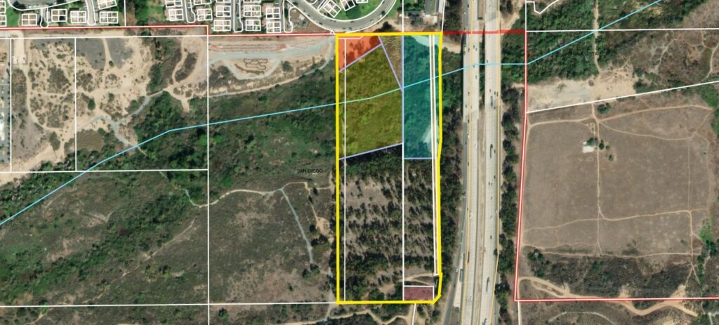
This project is creating plans to restore a 15-acre site within the OVRP. The site, currently a non-native eucalyptus grove, is targeted as a priority for restoration in the OVRP Concept Plan. The project team aims to create a set of shovel-ready plans that, once implemented, will improve wildlife habitat within the project site and improve connectivity to adjacent park property and surrounding neighborhoods.
The project’s main goals are to:
- Restore native habitat to support local wildlife, with an emphasis on native and at-risk species. Reduce air and water pollution, erosion, and fire risk through restoration.
- Enable native wildlife to connect both within the property and adjacent OVRP property through natural patterns such as water and airflow, as well as wildlife corridors.
- Improve water quality, availability, and drought tolerance through stormwater reduction, improved infiltration, and reduced erosion. This should be accomplished using nature-based solutions, to the extent feasible.
- Increase public access to enable more park use, especially by local community members, so they can directly experience native plants, animals, and supporting natural features.
- Create community engagement and stewardship, especially from grassroots groups and tribes/bands, getting their input and support for the plan.
Project Location
The site is located in the western section of OVRP. On one side, it is adjacent to Rt. 805, and the rest of it is surrounded by other parts of OVRP. Another side is close to, but not directly bordering, the Otay River.
Why is this project on the 30×30 list?
This project supports the 30X30 strategy by laying the groundwork for restoring land into an appropriate natural state. This works to improve biodiversity, boost climate resiliency, and increase public access to nature.
-
Protect Biodiversity: This restoration project will reintroduce and support native habitats within the 15-acre site, benefiting local wildlife, including native and at-risk species. The project will also improve water quality and habitat connectivity, both key facets of protecting biodiversity.
-
Boost Climate Resiliency: Implementing nature-based solutions such as stormwater reduction, improved infiltration, and erosion control will enhance the site’s drought tolerance and overall resilience to the impacts of climate change. Restored habitats with native vegetation will also be more resilient to fire and heat.
-
Increase Public Engagement and Access to Nature: The project will improve public access to the park, especially for underserved communities, by increasing opportunities for residents to experience native plants, animals, and natural features. Involving local grassroots organizations and tribal groups in the planning and stewardship processes also aims to boost community engagement and stewardship, promoting ongoing public participation with their surrounding natural environment.
How will this project be completed?
The Wildlife Conservation Board (WCB) awarded $409,000 to the Resource Conservation District of Greater San Diego County to lead the plan creation. The City of San Diego, alongside the County of San Diego and the City of Chula Vista, are the lead landowners.
The plan creation project began in December 2023. The objective is to complete it by January 2026 but there is leeway to complete it up until March 2027. Once the plan is completed, funding will be needed to implement the plan.